Virtual limnimetric station
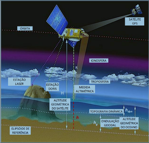
Principle of spatial altimetry
Any intersection of a continental water body with the ground track of a satellite equipped with an altimeter constitutes a potential virtual limnimetric station, capable of monitoring over time the evolution of the height of the water body in relation to an ellipsoid.
The principle of the measurement is summarized in Figure 1: the altimeter sends a pulse towards nadir and measures the time it takes for it to reflect on the Earth’s surface and return to the altimeter. Knowing the speed of wave propagation in the media traversed, this travel time makes it possible to calculate the distance (R) between the altimeter and the reflecting surface. Since the orbit of the satellite (and therefore its height H with respect to an ellipsoid) is known, the height of the reflective surface (h) with respect to the ellipsoid can be calculated (h=H-R). In practice, several corrections are made to the measurement to take into account disturbances due to the atmosphere, ionosphere and solid and liquid earth tides.
 |
|
|
The frequency of measurements along a satellite path depends on the mission: 10 pulses per second for Topex/Poseidon, 20 pulses per second for Envisat and Jason. The time difference between 2 consecutive passes depends on the repetitiveness of the satellite: 35 days for Envisat, 10 days for Topex/Poseidon and Jason, which conditions the lagtime between two readings of the time series of height of the inferred water body.
In addition, the density of the satellite’s ground tracks varies due to its repetitiveness: 90 km between 2 Envisat tracks at the equator compared to 315 km between 2 Topex/Poseidon and Jason tracks; hence a lower potential virtual station density for Topex/Poseidon and Jason than for Envisat. Figure 2 overlays the ground tracks of Topex/Poseidon and Jason (in red) with Envisat (in yellow) in an Amazon region.
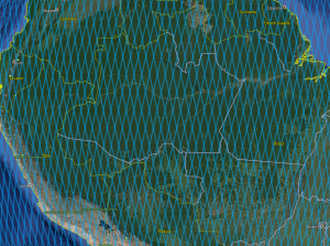 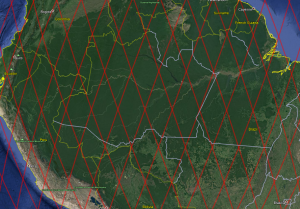 |
| Figure 2a : Envisat ground tracks (blue) and Figure 2b : Topex/Poseidon-Jason ground tracks (red) over Amazon region. |
A methodology for defining virtual stations is applied in the SO HYBAM in the proximity of in-situ stations and the associated height series are available here (choose “virtual” in the station type to be selected). This manual methodology was developed by research teams involved (among others) in the joint IRD/ANA project “Application of Space Hydrology to the Amazon Basin”, established under an agreement with the Brazilian Cooperation Agency (ABC). Work is underway to move towards a fully automated methodology.
The SO HYBAM site will also be used to disseminate data from other virtual stations produced by the teams associated with the Observation Service.
Creating a virtual station
VALS (Virtual ALtimetric Stations), a specially developed software, makes it possible to define a virtual station based on information provided by space agencies and to extract a time series of water levels after selecting from the instantaneous measurements (10 or 20 per second) those that represent the height of the water body. This methodology is described in the software manual and in various articles (see bibliography at the end of the page) and will not be repeated here but only illustrated by a few figures relating to the main steps of the method.
- definition of a study area around an intersection of a water body with a satellite ground track, using Google Earth (figure 3)
- extraction of the measurements positioned in the study area and representation of the altimeter measurement as a function of a distance along the satellite ground track (figure 4)
- manual selection of measurements representative of the water body (figure 4)
- extraction, from the selected measurements, of the time series which is then made available in the Data section of the SO HYBAM site (figure 5).
 |
| Figure 3 : Choice of a study area (the points are a sub-sampling of 20 points per second). |
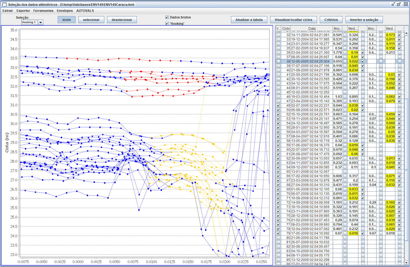 |
| Figure 4 : Selection of representative measurements; the points connected by a line correspond to the same cycle, the selected points are in red or yellow (hooking). |
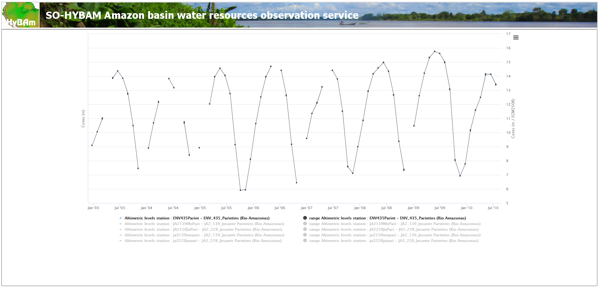 |
| Figure 5 : Time series extracted; time on the abscissa, height relative to the geoid on the y-axis. |
Format of the extracted altimeter height series
The data downloaded from the SO HYBAM website are downloaded as a text file, compatible with the csv format. Other formats will be available in the future. Figure 6 shows an example of an extracted file with the following meaning of the columns:
- id_station : code identifying the virtual station
- nom : name of the virtual station
- date : date and time of the measurement
- valeur : measurement in cm of the height of the water body in relation to the satellite reference ellipsoid
- incertitude : error in cm, estimated on the measurement
- origine : method used to calculate the representative value of the height from instantaneous measurements (to 1/20th of a second for Envisat for example):
-
- 0 : average height
- 1 : median height
- 2 : average of the heights with correction of the off-nadir effect (see bibliography)
- 3 : median of the heights with correction of the off-nadir effect.
- qualité : estimation of the measurement quality as a function of the number of instantaneous measurements used in the calculation method (i.e. selected in the vicinity of the virtual station) :
-
- from 1 to E : 1, 2, 3, … 14 measurements used
- F : more than 14 measurements used.
| id_station | nom | date | valeur(cm/EGM2008) | incertitude(cm) | origine | qualite |
| ENV435Parint | ENV_435_Parintins | 24/12/2002 01:48 | 909,40 | 0,50 | 1 | 4 |
| ENV435Parint | ENV_435_Parintins | 28/01/2003 01:48 | 1006,40 | 0,30 | 1 | 2 |
| ENV435Parint | ENV_435_Parintins | 04/03/2003 01:48 | 1100,60 | 3,70 | 1 | 3 |
| ENV435Parint | ENV_435_Parintins | 08/04/2003 01:48 | ||||
| ENV435Parint | ENV_435_Parintins | 13/05/2003 01:48 | 1387,20 | 2,50 | 3 | 5 |
| ENV435Parint | ENV_435_Parintins | 17/06/2003 01:48 | 1437,30 | 0,20 | 3 | 4 |
| ENV435Parint | ENV_435_Parintins | 22/07/2003 01:48 | 1385,50 | 0,20 | 3 | 4 |
| ENV435Parint | ENV_435_Parintins | 26/08/2003 01:48 | 1275,50 | 2,80 | 3 | 7 |
Figure 6 : Extract of the downloaded file with the height relative to the ellipsoid in cm and the uncertainty associated with the measurement.
Bibliography
Alsdorf, D.E., Rodriguez, E., Lettenmaier, D.P. « Measuring water surface from space ». Reviews of Geophysics, 45,1-24, (2007).
Calmant S., Seyler, F.,. « Continental surface water from satellite altimetry». C.R. Geosciences, 338, 1113-1122, (2006).
Calmant, S., Seyler, F., Créteaux, J.F. « Monitoring Continental Surface Waters by Satellite Altimetry ». In revision at Survey in Geophysics
Frappart, F., Calmant, S., Cauhope, M., Seyler, F. and Cazenave, A. « Preliminary results of envisat ra-2-derived water levels validation over the amazon basin ». Remote Sensing of Environment, 100(2), 252-264, (2006).
Kosuth, P., Blitkow, D., Cochonneau, G. « establishment of an altimetric reference network over the Amazon basin using satellite radar altimetry (Topex Poseidon) ». On 15 years of Progress in Radar Altimetry, Venice, Italy, ESA SP-614 July 2006, 8p, (2006).
Lee-L. Fu, Cazenave, A. Satellite Altimetry and Earth Sciences. A handbook of Techniques and Applications, Ed Academic Press, International Geophysics Series, Vol. 69, San Diego, USA , (2001).
Roux, E., Santos da Silva, J., Vieira Getiranaa, A. C., Bonnet, M.-P., Calmant, S., Seyler, F. « Producing timeseries of river water height by means of satellite radar altimetry – Comparison of methods ». In revision at Hydrological Sciences Journal – Journal des Sciences Hydrologiques.
Santos da Silva, Corrêa Rotunno Filho, O.J., Roux, E., Seyler, F., Calmant, S. « Níveis d’água nas zonas úmidas da bacia Amazônica estimadas por satelites altimétricos . II sympósio de Recursos Hidricos do Sul-Sudeste, 12-18 Outubro de 2008, Rio de Janeiro, (2008).
Wingham, D. J., Rapley, C. G., Griffiths, H. « New techniques in satellite altimeter tracking systems ». Proceedings of IGARSS’86 Symposium, Zurich, 8 –11 Sept. 1986, Ref. ESA SP-254, 1339–1344, (1986).
Zelli, C. « ENVISAT RA-2 advanced radar altimeter: Instrument design and pre-launch performance assessmentreview ». Acta Astronautica, 44, 323– 333, (1999).